Half a century ago, Liberty Lake was struggling.
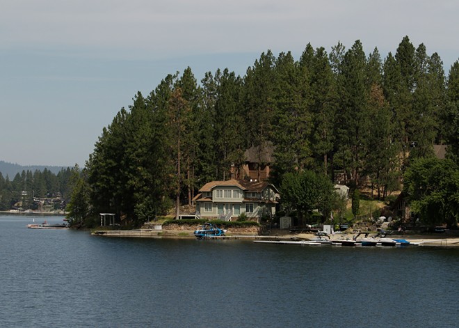
With few rules protecting the lake from development, many of the once rocky, tree-filled shores were swapped for sandy beaches and lake houses with green lawns and septic systems that allowed pollutants to run off into the lake. The shallow water body — only 30 feet at its deepest — regularly struggled with algae blooms and poor water quality.
But then, with passage of the Washington state Shoreline Management Act and the creation of the Liberty Lake Sewer and Water District in the early 1970s, things started to improve.
The water district installed sewer lines around the lake to capture and treat wastewater, dredged out polluted sediments, and applied alum to control the algae and help clarify the waterbody in a first-in-the-country restoration treatment.
Around the same time, Spokane County was required to create a Shoreline Master Program and a map that designated protections along each stream, river and lake in the county. The map, which is updated periodically, restricts the types of development that can take place and dictates how much natural vegetation needs to be protected near the water.
Now, the owner of one of the few Liberty Lake properties designated as a "natural" shoreline — the most restrictive category — has requested a change to the map that he says would better recognize how his land was used in the past. But neighbors worry that change could negatively impact some of the "last remaining natural shoreline" and the overall ecological function of the lake.
In a nutshell, the requested map amendment would potentially allow the owner to build 50 feet closer to the water.
"The requested change completely disregards and violates the decades long community wide efforts undertaken to restore, preserve and protect Liberty Lake for future generations," the three elected Liberty Lake Sewer and Water District commissioners wrote in a July 20 letter to the Spokane County Planning Commission.
But the property owner, Dan Spalding, says he intends to respect the land, which has already been used as a summer camp and wedding venue for decades, and is home to a century-old lodge.
He argues that there's little evidence that building 200 feet back from the high water mark, as the "natural" designation requires, is any more beneficial for the lake than building 150 feet back, which would be allowed under the "rural conservancy" designation he's requested.
"The idea that if they grant this amendment this 50 feet is going to make this massive difference in the quality of lake water is misguided," Spalding says. "And it's not going to make a significant difference in the appearance or experience from the water."
The Spokane County Planning Commission held a public hearing on the requested amendment on July 27, receiving several comments opposed to the change.
"It is well known and established science that land development increases nutrient loading in the watershed," says the water district's letter, referring to chemicals that can run off from developed areas such as fertilizers, which can increase algae. "As development moves closer to the shoreline, nutrient loading impacts increase. The 52 acres being considered are the last undeveloped portion of the shoreline."
The only other remaining natural shoreline that's protected is part of Liberty Lake Regional Park, also on the southern end of the lake.
Other public comments sent to the commission worried that any development enabled by the change would remove a natural path to the water for wildlife from the nearby landlocked Mackenzie Natural Area, while others criticized the idea that the change could financially benefit Spalding.
"Almost every comment I heard and read came from people who live within 50 feet of the lake," Spalding says, noting those homes are far closer than he'd be allowed to build if the amendment passes. "It's a bit like, 'I got mine, and now I want to cruise by and enjoy the unsullied acreage that you paid for.'"
After discussing the request in depth, the Planning Commission opted to ask for more information and could discuss the matter again later this month. Some were unsure Spalding showed enough reason for the change to be made, and some wanted to know whether the amendment could open the door to changes on other sensitive shorelines in the county.
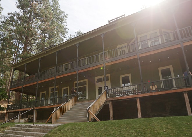
The property in question is home to Zephyr Lodge, likely the oldest building on the lake, constructed around 1902. It was first used as a hotel and dance hall, surviving the speakeasy days before being sold in the 1940s to a Christian group that used the lodge and some small cabins near the shore as a summer camp, retreat and wedding venue.
Spalding — who owns multiple buildings in downtown Spokane, including the Longbotham Building on East Main Avenue that he renovated after purchasing it in 1993 — bought the lakeside property in 2016, and got the previous uses grandfathered in by the county. The property is still used for weddings and events.
Because of those historic uses, Spalding notes that the property isn't a pristine natural area.
To help make his case for the amendment, Spalding is working with John Pederson, the former planning director for Spokane County, who filed the application with the county.
In a presentation to the Planning Commission before the July 27 public hearing, Pederson argued that he and others at the county made an error when they updated the shoreline map in 2013 and designated that property as "natural." Originally, that designation didn't exist, and the property was designated as "pastoral," and when the update happened, Pederson says he and others relying largely on aerial maps weren't aware of the buildings there.
But some of the planning commissioners questioned the veracity of Pederson's claim that it was a mistake.
Contrasting with Pederson's narrative, BiJay Adams, the general manager for the sewer and water district, told the commission that he was part of the group that helped update the map in a yearslong process, saying that they did consider the historic uses before consciously designating that area with the protective "natural" label.
Adams, who has worked for the water district for 21 years, says that allowing more intensive uses along the lake defies the mission of the sewer and water district, which is to protect the lake.
"An increased buffer allows for more opportunity for nutrients to not make their way directly to the water body," he says.
Ultimately, Spalding says he hopes to put four buildings on a portion of the property that is largely covered in trees and shrubs, with steep terrain leading down to the shoreline. That plan will have to go through a separate public process and is not part of the requested amendment.
Under the county zoning for that area — a separate set of rules that won't change with the amendment to the shoreline map — Spalding can ask to build four clustered homes, each on 10 acres. He says that plan could help reduce impacts on the land by keeping the buildings closer together while maintaining most of the landscape as it is.
Due to the topography of the landscape, Spalding says it's more logical for two of those four buildings to be near the 150-foot setback, while the others would likely still be 200 feet or more from the water.
Spalding also notes that current regulations are far more stringent than what other properties around the lake faced when they were built, and he says he respects the sewer and water district's work to protect the lake.
"There will be no lawns or fertilizing and pesticides and so forth because it's not allowed," Spalding says. "I wouldn't do that anyway. I think it's ridiculous to turn a lakeside landscape into something that belongs in the Valley."
"What one person might say and how it ends up coming to be are often two different things. I've seen it over and over again with regards to development on the shoreline."
tweet this
Whether he ultimately builds the homes 200 feet or 150 feet from the water, Spalding says he'll be required to build swales to ensure stormwater that runs off of the homes can filter into the soil properly.
"To be honest with you, if these are built like I'd like to do it, once they're done the only people it would ever affect are the people living there," Spalding says.
Still, the water district is concerned that any new development has the potential to further impact the lake's health. Adams says he's seen many developers over the years go beyond what was expected or promised when they were granted exemptions.
"What one person might say and how it ends up coming to be are often two different things. I've seen it over and over again with regards to development on the shoreline," Adams says. "I think the ultimate protection is to maintain the designation. ... The lake has suffered its impacts, and we can't just keep doing it."
Spalding says he understands the district has to take an aggressive stance to make sure the lake is protected.
"They've done a great job," Spalding says. "The water has improved so much since I was a kid out there."
But in this case, he says the concern that he's the big bad wolf coming in trying to make some secretive or major changes isn't true.
"This is just a practical matter," Spalding says. "If we get it, great. If not, I can say not much changes in either case on a practical level."
Once the Planning Commission makes a recommendation to approve or deny the requested amendment, the Board of County Commissioners will vote on it. Then, if needed, it would go to the state Department of Ecology for final approval. ♦


