On Jan. 26, 1700, one of the largest earthquakes in human history struck off the West Coast of the United States, causing a tsunami and significant changes to the coastline from southern British Columbia to Northern California. Scientists estimate the earthquake hit a magnitude 9 on the logarithmic scale that we now use to measure earthquakes. That would easily put it in the top 10 ever recorded.
Although the area was not widely populated at the time, scientists have pieced together what happened that day through geological and tree records, as well as a surprising source: Japan's history. A tsunami also hit the eastern Japanese coastline that day. It wasn't until the 1980s and '90s that scientists realized that the Japanese "orphan tsunami" in 1700 was caused by a large earthquake in the Pacific Northwest.
"From that we were able to find out exactly the day and time of when Cascadia last ruptured here in Washington state, which was on Jan. 26 in the year 1700," says Corina Allen, chief hazards geologist with the Washington state Department of Natural Resources. "And then lo and behold, they were able to date trees from coastal Washington and find that they all died in the winter of 1700, which really corroborates that story."
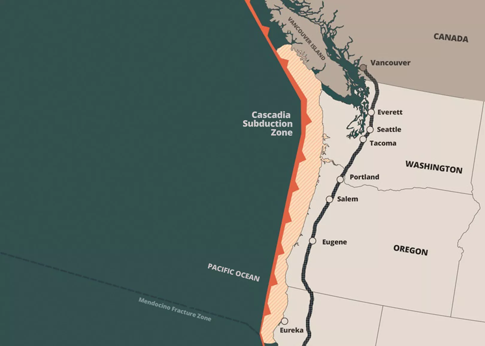
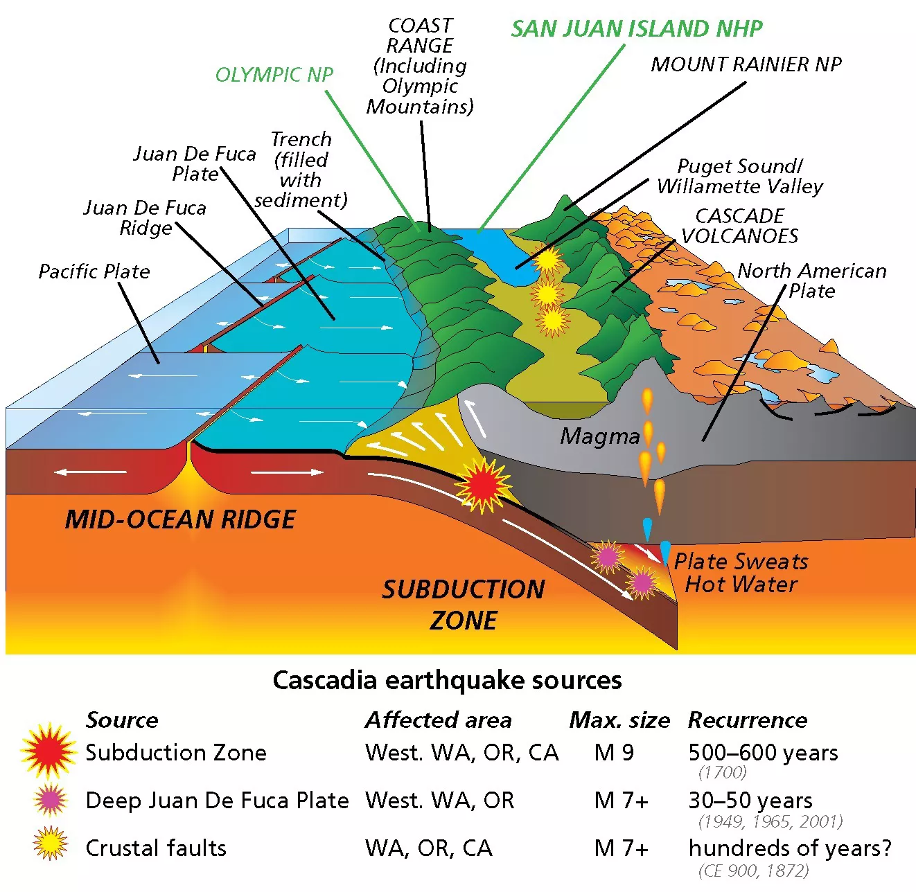
The earthquake was caused by the Cascadia Subduction Zone, the faultline where the Juan de Fuca Plate moves beneath the North American Plate. The Cascadia Subduction Zone fault is 700 miles long, running from northern Vancouver Island, British Columbia, to Cape Mendocino, California. The movement of the tectonic plates causes a buildup of pressure, which means eventually another earthquake will happen in the same region.
"By looking at the geologic record and past tsunami deposits and evidence of land level change, we're able to understand how frequently these large earthquakes happen," Allen says.
Emergency managers have been planning for that next earthquake for years, often dubbing it the "Big One." Scientists estimate that similar quakes in the Cascadia Subduction Zone have happened every 200 to 1,000 years, and since the last one occurred more than 300 years ago the Pacific Northwest could be due for the next major change to the Earth's crust.
The next Cascadia Subduction Zone earthquake will likely be just as large as the last one, but this time an estimated 15 million people live in its path.
When it happens, buildings will collapse, roads and runways will crack, bridges will fall down, and means of communication in and out of the area will cease. The earthquake will instantly set off a tsunami that could reach parts of the Washington coast in as little as 10 minutes.
"It is absolutely a 'when,'" scenario, says Chandra Fox, deputy director at Spokane County Emergency Management. "When the Cascadia Subduction Zone breaks, when we have that seismic event, it will be hands down the worst disaster that the United States has ever seen, let alone Washington state. It will be worse than [Hurricane] Katrina. It will be worse than Superstorm Sandy. It will be the worst thing because we'll be talking an area of impact from southern British Columbia through Oregon into Northern California. That's millions and millions and millions of people."
Fairchild is considered a secondary intermediate staging base for a Cascadia earthquake, while Grant County International Airport in Moses Lake will be the primary staging area.
Those who survive the initial earthquake and tsunami may become victims of the aftermath. Beyond the aftershocks, roads could be undriveable, airports closed, and the destruction of transportation options will affect food supplies, water supplies, and the ability to get in to help or out to safety. It's expected that many bridges along Interstate 5 and other main roads will be damaged or destroyed completely.
Gas pipelines are likely to sustain damage, with an expected restoration time from a few days for areas that are inland to weeks or months along the coast. Power outages are expected to be widespread within 100 miles of the coast across the entire Pacific Northwest. Water is not expected to be restored for three to seven months. Telecommunications (cell towers, cables and antennas) are expected to be knocked out for two to three months in the Pacific Northwest, Alaska and even East Asia.
Eastern Washington will mostly be spared from the initial impact, mainly because of natural barriers between the west and east side of the state. According to Nathan Wood, a supervisory research geographer at the U.S. Geological Survey, the tsunami will likely enter the Columbia River Gorge but will quickly lose energy because of a sandbar under the river. The Cascade Mountains will also absorb much of the earthquake, so it won't be felt as strongly to the east.
Because it will be spared the worst of the damage, Eastern Washington will need to take the lead for the emergency response in the aftermath of the quake, including taking in refugees from the destroyed and damaged areas and sending support to Western Washington.
"The impacts for us are going to be: How do we manage in the aftermath?" Fox says. "Spokane County is going to be one of the hubs for resources coming into the area."
SPOKANE TAKES THE LEAD
Scientists have studied other 8 to 9 magnitude subduction zone earthquakes, including events in Chile in 1960, Alaska in 1964, Sumatra in 2004 and Japan in 2011. A 9.0 magnitude subduction zone earthquake could cause shaking for six to 10 minutes, hazards geologist Allen says."It's an incredibly long duration of shaking," Allen says. "They also [involve] very, very strong shaking because they are rupturing near the surface of the Earth."
A 2022 Federal Emergency Management Agency (FEMA) Region 10 Plan found that, if the earthquake and tsunami were to happen tomorrow, more than 13,800 people could die and 107,000 could be injured. The economic impacts in Washington, Oregon and California could exceed $70 billion.
For context, in the 1960 Chile earthquake, around 1,650 people died; in the 1964 Alaska earthquake, around 140 people died; in the 2004 Sumatra earthquake and tsunami, it's estimated around 280,000 died; and in the 2011 Japan earthquake and tsunami, it's estimated more than 20,000 died.
The Spokane County Emergency Management office is housed under the county sheriff's department. The office maintains service contracts with all 13 municipalities in the county, and manages the county's Comprehensive Emergency Management Plan and Hazard Mitigation Plan. The county's emergency management team plans for a broad list of natural hazards: wildfires, flooding, landslides, windstorms, severe winter storms, drought, volcanoes and earthquakes. Team members also plan for human-caused dangers such as domestic terrorism and transportation accidents involving hazardous materials.
Fox has been in emergency management for more than 25 years. For much of that time she worked on the state's west side, which informs her understanding of the dangers of the faultline. Although there are plenty of Cascadia Subduction Zone earthquake scenarios being planned for, no one can truly know what will be needed until the event actually happens.
Spokane County (and any other outside entities) will most likely not be able to help with the immediate aftermath of the earthquake and tsunami, due to roads and airport runways being destroyed as well as resources being severely limited. But it will become the state's Emergency Operations Center (EOC).
Washington's catastrophic plan includes memorandums of understanding with Spokane County, Spokane Community College and the National Guard Readiness Center to use their facilities to reconstitute the state Emergency Operations Center in Spokane. It is currently located at Camp Murray outside Seattle.
It wasn't until the 1980s and '90s that scientists realized that the Japanese "orphan tsunami" in 1700 was caused by a large earthquake in the Pacific Northwest.
"The EOC is the place where all of the state agencies send representatives so that they can determine the resource needs," Fox says."Which is the best agency to fill those needs? And if we don't have those resources, where are we going to source them from? And if we have to source them from outside of the area, how are we going to get them here?"
The state of Washington takes the faultline seriously and two years ago conducted the Cascadia Rising 2022 exercise to prepare for potential scenarios. The priorities immediately after the earthquake and tsunami include: critical transportation, mass care services, shelter, water and nutrition.
Responders will focus on the coastal impacts of the earthquake and tsunami; interior impacts, including damage throughout the I-5 corridor; sheltering displaced people; and coordinating local, state, tribal, and federal support from inland areas.
Much of the fuel (both gasoline and natural gas) in Spokane County comes from the east, which in itself will reduce negative impacts for Eastern Washington, but the area may be responsible for providing Western Washington with supplies.
"Before you can worry about getting commodities and supplies to individual people, you first have to have that broad understanding of what the situation actually is: How much damage do we have? What are our transportation corridors that are still passable?" Fox says. "We have lots of pipelines in the area, which could be a potential problem. My concern is are we going to have agreements with Idaho or even with Montana? Do we have the ability to regulate the flow of traffic? Because there are resources and things that we're actually going to need."

EAST AND WEST
Planning for the different scenarios is an ongoing process — on both sides of the state. Rather than traveling to the west side of the state to help, those unaffected in Eastern Washington will be tasked with helping victims who arrive in the area. One potential scenario is a mass exodus of people traveling from the west to the east side of Washington, but with the destruction on the west side — specifically to roads and runways — it's not clear how difficult it will be for people to get out. One crack in a road, bridge or runway can mean no travel in either direction until it's repaired."DOT is becoming more willing to take a hard look at the realities of the transportation corridors," Fox says. "Driving [on] I-90, you've got at least a dozen overpasses just to get out of the [Seattle] city proper."
Because of the potential damage, the only first responders traveling in (at least for a while) will be military, with Fairchild Air Force Base becoming one of the most important centers of operation.
Fairchild is considered a secondary intermediate staging base for a Cascadia earthquake, while Grant County International Airport in Moses Lake will be the primary staging area. Because of this, the Department of Defense will also be an important partner with Spokane County and other agencies in Eastern Washington.
Thousands of residents in Washington and Oregon will not be able to receive outside assistance for days, weeks or even months. First responders and local police will be overwhelmed, with many coastal police stations expected to be destroyed or inoperable. Local first responders are expected to provide immediate support after the events, but there may be a shortage of help due to staff being impacted in the aftermath. Once first responders in Eastern Washington and Oregon are able to travel to the areas, they will help with relief, but it will take time for them to get there.
Affected residents are expected to be without utilities for at least 72 hours, with only local utility workers able to help. Repair to both electric and natural gas infrastructure is expected to take months or years.
"The best way to look at it is: How do you manage the needs of the people coming out with the imperative of getting the necessary response and recovery resources in," Fox says. "Especially when there's limited transportation corridors, which we know will happen."
According to Fox, outside first responders will also arrive when they are able. But some outside help could actually slow the progress happening in the area.
"You will have people who will self-deploy, who just want to come help," she explains. "If you're going to come into this type of disaster area where the damage is this extensive, you need to be prepared there to fully take care of yourself. Because the Best Western is not going to be available to you."
When roads are finally open, the government or other aid organizations may ultimately organize mass transit to other areas, which could cause a dramatic change in the population of Spokane County for decades.
"There will be areas that will be unlivable for who knows how long, and I don't know what the movement of the population will look like," Fox says. "If you look at Katrina as an example, there are still areas in New Orleans that have never been repaired. There are also areas in New Orleans that have been gentrified, so the people who originally lived there were evacuated out, they lost their homes, and they couldn't afford to come back in."
Fox explains that her office's job after a Cascadia Subduction Zone earthquake is to primarily provide support and assistance that the state Emergency Operations Center is going to need and secondarily to help mitigate any impacts on Spokane County residents.
"What type of strain are they going to be putting on our infrastructure? Are they going to need sheltering? Are they going to need fuel?" she asks. "That's what we're looking at in terms of tax to us."
THE CASCADIA SUBDUCTION ZONE
As scientists have pieced together the history of the Cascadia Subduction Zone, they've found at least seven major earthquakes in the last 3,500 years, occurring anywhere from 200 to 1,000 years apart. The last one was 324 years ago.According to the Washington Department of Natural Resources, there's about a 10% chance that a 9.0 magnitude earthquake will occur along the Cascadia Subduction Zone within the next 50 years.Although the earthquake itself will cause a lot of damage, the potential for a tsunami is also a major concern. According to USGS research geographer Nathan Wood, the wave will show up at different times in different locations, because the fault does not run perfectly parallel to the coast.
"When the plate firmly beneath North America finally releases, it's pushing the water column above it, and that causes the tsunami," he says, explaining that the Juan de Fuca also moves under the North American plate at an angle. It's known as an "oblique subduction," meaning it doesn't move underneath at a 90-degree angle, Wood says.
Some locations such as Crescent City, California, may be closer to where the fault starts to move and could experience a tsunami in as little as 10 minutes.
The damage will depend on where along the fault the earthquake occurs. Corina Allen, the chief hazards geologist with the Department of Natural Resources, says the earthquake could happen on one area of the fault or along the entire fault. Or the earthquake could happen at the north side and "unzip" all the way down the fault, or vice versa. That will affect how the tsunami hits different places.
"If you're on the Long Beach Peninsula, then you have 15, 20 minutes probably, and you're talking about thousands of people," Wood says. "You're talking about something like 5,000 people in Ocean Shores that just won't have enough time to make it out."
The Department of Natural Resources has created simulations of potential tsunami impacts after the massive earthquake.
"The tsunami is generated instantly when the earthquake starts and travels out in all directions from the initiation point, from where the earthquake starts," Allen says. "So it travels across the Pacific Ocean towards Japan, and it travels landward towards the Washington coastline."
According to one simulation, after the earthquake starts, a tsunami could hit the coastline around the La Push area on the Olympic Peninsula in around 10 minutes and the southern Washington coastline in around 15 to 20 minutes. It would then travel through the Strait of Juan de Fuca, hitting Port Angeles in 45 minutes, Port Townsend in one hour, and then traveling through the Puget Sound toward Bellingham. In that scenario, it would hit Seattle about two hours and 20 minutes after the earthquake, then continue south toward Tacoma and Olympia.
Allen says that there will likely be very strong currents within the Puget Sound, some inundation in places like the Port of Tacoma and other low-lying areas like the Skagit Valley, and very widespread water inundating coastal communities in southwest Washington and major river valleys.
According to the 2022 FEMA report, 36% of Oregon and 42% of Washington coastal county populations currently live in the inundation zone. That does not include tourists or other visitors who significantly increase the population along the coast during the warmer months. Hundreds of miles of coastline would be subject to complete devastation.
"The event directly affects more than 140,000 square miles in three states, two FEMA Regions and parts of British Columbia, Canada. Indirect impacts are also likely in Alaska," according to the FEMA Region 10 report. "The tsunami affects 27 counties and 17 tribes, including those along the Puget Sound and Columbia River. Additional tsunamis resulting from the initial shake continue for a minimum of 12 to 24 hours, causing inundation and strong currents along the outer coast and to coastline communities."
INFRASTRUCTURE & AFTERMATH
The aftermath could multiply the effects of the earthquake and tsunami, depending upon the time of year and location. Aftershocks, fire, hazardous materials spills, landslides and avalanches are all significant threats to the region. Allen says that although a subduction zone earthquake has never been recorded triggering a volcano, it's not impossible.For those in the earthquake zone, officials are also worried about aging infrastructure.
"Old bridges, old pipelines, old wastewater, all the old pipes that are out there," are concerning, says USGS research geographer Wood. "Not every bridge is going to collapse, but it might be several days before they have engineers who are able to get out there to be able to look at the bridge and say, 'Yes, we clear this one for travel.'"

And because many roads and bridges will be closed, the ones that remain open will likely be reserved only for emergency responders. Many un-reinforced (mainly brick) buildings that have no rebar or other retrofitting will crumble during the initial earthquake.
"When earthquakes happen, they shake all that mortar out, and then the bricks just fall," Wood says. "There are still a lot of unreinforced brick buildings in the Northwest."
Allen says much of the infrastructure in Washington was built before the widespread adoption of building codes around the state in 1975. The Cascadia Subduction Zone was not widely studied until the 1980s and 1990s, and earthquake standards for construction near the subduction zone and the Seattle Fault weren't incorporated into Washington building codes until 2005. Many buildings built before then were not built to withstand a major earthquake.
"Even now we're learning more and more about basin amplification. So there's [building] codes that are constantly being adopted and adapted as we learn more about the potential shaking hazards from these large earthquakes," Allen says. "And so exactly what will happen, we don't know, but we can expect that there will be widespread damage to buildings and infrastructure."
"Seattle itself has done a lot of work over the last decade or so in addressing and mitigating their unreinforced masonry," Fox says. "Most of Seattle is unreinforced masonry."
After the earthquake and tsunami, the land will naturally drop at the coastline. How far will depend on how close the land was to the faultline, but there are estimates that the Northwest coast could drop two to three feet in elevation.
"The Northwest coast will naturally just drop because of the seismic energies released," Wood says. "You wouldn't be like 'I'm in freefall,' but now your daily tides are going to be going in further than they used to go. We will lose some land, but we won't lose it physically — it's still there, but you're going to lose it for use because you'll get a lot more land sitting in the intertidal zone."
EDUCATION
The states of Washington and Oregon have invested a lot in educating the public, especially those who live on the coast. Their education includes information on how tsunamis work, what to look for, and why you should have a supply of food and water for when they happen.The education provided has emphasized the importance of go-bags and extra supplies. Fox stresses that each person may be responsible for themselves, at least for a while.
Longtime Washington residents remember the 6.8 magnitude Nisqually earthquake that occurred northeast of Olympia in 2001.
"That earthquake happened and within 15 minutes, I-5 was a parking lot," Fox remembers. "There were so many people who had just immediately gotten in their cars and tried to go home, and that was a relatively small earthquake. [The Cascadia earthquake] truly will be the worst day that anybody's seen, and it will be a generational recovery. It's going to be a really bad day."
Even for those who are training to respond, that practice doesn't always happen in the rain or snow or in the middle of the night, and reactions will vary. That's why it's important to make a plan, and revisit it regularly to keep the details fresh and ensure supplies are handy.
"That [2001 Nisqually] earthquake happened and within 15 minutes, I-5 was a parking lot."
"You're trying to encourage them to do their preparedness because you don't want them just to throw up their hands and say, 'Oh it's not going to matter,'" Fox says. "Well no, it actually does matter and it is important, and we need you to do it because the better prepared you are the more likely it is that you will have a positive outcome." ♦